It should be noted that the abstracts were prepared by speakers exclusively in English (last year about 85 percent of reports were presented in English). 147 reports were selected for participation in the conference, of which 127 were prepared by participants from Ukraine.
The following persons were invited to deliver the welcoming speech and open the conference:
- M.A.Yakimchuk - Corresponding Member of the National Academy of Sciences of Ukraine (Geology of Combustible Minerals), Associate Professor, Doctor of Technical Sciences;
- A.V.Kendzera - Deputy Director of the Institute of Geophysics, Corresponding Member of the National Academy of Sciences of Ukraine (Seismology), Senior Researcher, Ph.D. in Physics and Mathematics;
- A.P.Petrovskyi - professor, doctor of physical and mathematical sciences, vice-president of the Ukrainian Oil and Gas Academy;
- V.A.Mykhailov - Director of the Institute of Geology at the Taras Shevchenko National University of Kyiv, Professor, Head of the Department of Geology of Mineral Deposits, Doctor of Geological Sciences;
- Zdenek Calabi - Researcher at the Geonika Institute at the Czech Republic Academy of Sciences, head of the geophysical laboratory, associate professor, professor at the Technical University of Ostrava.
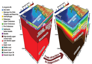
The first speaker of the plenary session was M.A.Yakimchuk. Mr. Yakimchuk prepared a report on the geophysical exploration of hydrocarbon accumulations in the Ukrainian Maritime Antarctic expedition in 2018. The results of geophysical surveys in the Ukrainian Maritime Antarctic expedition in 2008 from the ship on the route Cape Town Port (South Africa) - Falkland Islands - King George Island, as well as on a training ground in the region of the Antarctic Peninsula were analyzed. The studies were carried out using mobile and direct geophysical methods and were aimed at studying the deep structure of the oceanic lithosphere along the ship's route, identifying possible accumulations of hydrocarbons and other minerals.
The use of this technology can have a significant impact when searching for industrial accumulations of hydrocarbons in unconventional water bodies (including areas of shale distribution, coal formations, and crystalline rocks). Mobile technologies can also be successfully used for studying poorly studied areas and blocks within the known oil and gas fields, as well as for the rapid detection and mapping large concentrations of hydrogen in areas of intense hydrogen degassing.
Professor Zdenek Calabi made a presentation on the topic “Metadata of geophysical data sources in the Czech Republic: research in IGN".
Geophysical data are used in many sectors of human activity, for example, the research and study of geological structures, the survey of drinking water sources, the survey of mineral raw materials, although these data are also used in other industries, such as environmental protection, civil engineering and archeology. However, the data were open and accessible only to a limited extent within the framework of international scientific networks.
By approving the INSPIRE Directive (Spatial Information Infrastructure in Europe), EU Member States have undertaken to provide access to digital geoscience spatial data with a single description of metadata. INSPIRE defines 34 topics for environmental data. Geophysical data are included in the topics of Geology and Natural Risk Zones. Thus, a separate topic for the provision of geophysical data in the Czech Republic in accordance with INSPIRE requirements was created as part of the CzechGe/ EPOS project
The CzechGeo /EPOS project contributes to the creation of a modern European spatial data infrastructure. Using INSPIRE principles, geophysical data has become available, compatible and reusable across institutions and national boundaries. At the same time, the data is under the control of their provider in terms of licensing and updating. As shown by seismological data, this can provide good resource information for creating new syntheses and applications.